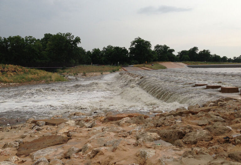
What Is a Flash Flood?
A flash flood is a sudden flood that can take just a few minutes or several hours to develop.
Flash floods typically happen in areas that receive sustained rainfall over several days or a large amount of rain in a short time. However, they may also occur when a dam or levee fails.
Flash floods are the number one storm-related killer in the United States.
Roughly 1 in 6 flood deaths that occur in the U.S. happen in Texas.
More than half of all flood deaths occur when people drive into floodwaters.
Male Texans are nearly twice as likely as female Texans to die in vehicle-related flood accidents.
As little as six inches of moving water can knock you off your feet and make a vehicle difficult to control.
Most cars can be swept away in as little as 12 inches of moving water.
Flood watch means be prepared
A Flood Watch is issued when conditions are favorable for flooding. It does not mean flooding will occur, but it is possible. When there’s a flood watch in your area, you should be prepared to take further action, such as evacuation, at a moment’s notice.
Flood warning means take action
Flood Warnings and Flash Flood Warnings are issued when a flood is imminent or already happening. Pay close attention to local weather updates and follow evacuation instructions quickly.
Source: National Weather Service
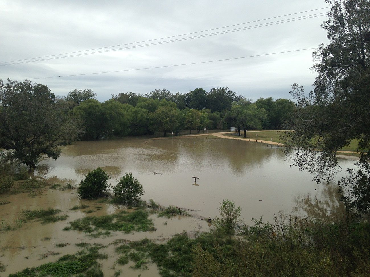
Why Floods Are So Frequent and Dangerous Here
San Antonio and Bexar County sit in a region known as Flash Flood Alley, which stretches along the Balcones Escarpment from the Dallas-Fort Worth area, through the Texas Hill Country, and into South Texas.
The climate and topography of this area make it prone to sudden, intense flooding. A mixture of warm air from the Gulf of Mexico and cool air from the north creates an unstable atmosphere, making it difficult to predict the amount of rainfall.
Shallow, clay-rich soil and limestone bedrock make the ground in this region slow to absorb water. Long periods of drought harden the soil, making its absorption even slower.
This region also contains some of the fastest-growing cities and towns in the U.S. Increasing development leads to more ground covered with asphalt and concrete, which increases the amount of stormwater runoff.
Flash floods occur as rainfall runs off the surface toward the nearest waterways. In areas with steep hills and rocky terrain, floodwaters can move especially fast, making flash floods even more dangerous.
Be Prepared for Floods
Subscribe
Create an account and sign up to receive alerts at SARiverFlood.org. See the next section on this page for instructions on how to read the map and get alerts.
Check
Check local floodplain maps to see if your home is in a flood-prone area. Consider getting flood insurance to protect your property—even if you rent your home or live in a low-risk area.
Plan
Make an emergency plan for your household. Record your emergency contacts, meeting places, and medical providers in one place. Carefully consider all family members’ needs, especially children, elderly people, and those with disabilities. Print and make extra copies of your plan.
Create
Create an emergency supply kit with a few days worth of necessities for your family members and pets. Prioritize non-perishable food, clean water, prescriptions, medical supplies, and a first-aid kit. If you don’t have one already, buy an emergency weather radio powered by hand crank or solar.
Protecting the Most At-Risk Individuals
Some members of our community are especially vulnerable to flood dangers, including unhoused people, individuals with disabilities, children, and elderly people.
When making flood safety plans, consider if any member of your household may need extra help preparing or evacuating, and plan accordingly.
If you are unhoused and flooding is possible, move to higher ground or find the nearest shelter. If you can access a phone, dial 2-1-1 to connect with local social services and find emergency housing.
If you have a family member or friend who is unhoused, reach out to them and see what you can do to help them stay safe.
How to Use
SARiverFlood.org
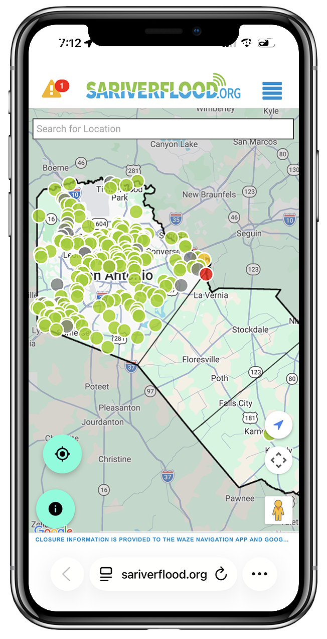
SARiverFlood.org shows road conditions at low water crossings across the region, using advanced sensors and gauges installed through a partnership between Bexar County, the City of San Antonio, and the San Antonio River Authority.
How to Read the Map
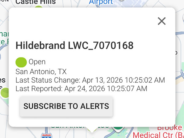
Each dot on the map indicates a location of a high water alert sensor, which detects rising water and automatically updates the map.
- Green means the road is open and safe to travel.
- Yellow means the water is rising.
- Red means the road is closed.
- Gray means that the sensor is inactive.
Sign Up for Alerts
When water rises to certain levels at those crossings, emergency alerts will be sent to those who have signed up to receive them.
To sign up for alerts, first create an account using your email address. Once your account is created, you can add a phone number and choose whether to receive alerts by text message, email, or both.
Click on individual dots on the map to sign up for text or email alerts. Sign up to receive alerts for low water crossings near your home, work, schools, and any other routes you or your family members travel regularly.
Use Google Maps or Waze
Sensor and gauge data that updates the map at SARiverFlood.org is also integrated with Google Maps and Waze. If you use these apps to navigate while driving, they will show when roads are closed due to flooding and suggest alternative routes.
Ways to Stay Safe Before, During, and After a Flood
- Check reliable weather sources like weather.gov, and stay tuned to local radio or television stations providing updates.
- Charge cell phones and other necessary devices in case you lose power or need to evacuate. Check batteries in flashlights, portable radios.
- If you have an emergency weather radio, tune into frequency 162.550 to get updates from San Antonio’s National Weather Service office.
- If you have to drive anywhere, check SARiverFlood.org to see if the roads are safe to travel.
- If you are instructed to evacuate your home, turn off the power, gas, and water, and unplug appliances before you go.
- Stay tuned to local news via radio or television. Pay close attention to safety instructions, and obey evacuation orders.
- Don’t attempt to walk through moving water. Just a few inches of fast-moving water can knock you off your feet.
- Turn Around, Don’t Drown®. If you see water covering the road, turn around and find a different route.
- If your car is trapped in fast-moving floodwater, stay inside. If water is rising inside the car, get to the roof.
- Avoid water that may have electricity in it. Stay away from downed power lines. Don’t enter any room where water is covering electrical outlets or power cords are submerged.
- Continue to monitor the weather, and stay tuned to local radio or television stations for updates and instructions. Return home only when authorities say it’s safe.
- Contact your family and loved ones to update them on your safety and location.
- Avoid driving unless it’s necessary. If you do, pay close attention to road closures and other cautionary signs. Check SARiverFlood.org to see if any roads along your route are closed.
- Do not enter any flood-damaged building without being told it’s safe first. Don’t enter a flooded home while the electricity is on.
- Avoid walking through standing water, as it may contain toxins, chemicals, or sharp objects that can hurt you.
- When cleaning up after a flood, wear protective equipment such as hard hats, goggles, waterproof steel-toe boots, heavy work gloves, and N95 masks.
More Flood Safety Resources
Want to learn more, and help spread useful information about flood safety? Find links to more resources, including downloadable planning materials, educational tools, and a Floods Don’t Care digital toolkit.